
I recently noticed an old Louisiana land document for sale on eBay. It concerned property located near the confluence of Bayou Teche and the Atchafalaya River. (What is called Bayou Teche on this map is today called the Lower Atchafalaya, the Teche now regarded as flowing into the Lower Atchafalaya at Patterson.)
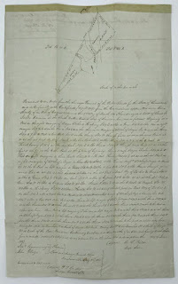 |
| The old Louisiana land document. (Source: eBay.com) |
In other words, the document concerns land near the present-day community of Baldwin, across the Atchafalaya River from present-day Morgan City.
Note the document’s hand-drawn map. Written across parcels spanning both "Bayou Teche" and the Atchafalaya is the name "Jacko Derouen." (Yes, Jacko, as in Michael Jackson’s nickname — though I expect the south Louisiana "Jacko" would have pronounced his name the French way: ZHAH-KO.) Jacko Derouen’s full name also appears below the map, in the actual text of the document.
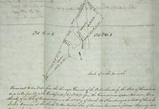 |
| Close-up of the hand-drawn map. (Source: eBay.com) |
I believe this document answers a question of mine I’ve had for some years: Why in the 1700s was an expanse of land in that region called "Prairie de Jacko"?
From my previous research I knew the toponym appeared in Thomas Hutchins’ 1784 book An Historical Narrative and Topographical Description of Louisiana and West-Florida. In that work Hutchins stated "3 miles below the Tage [Teche] river on the western side is a large savanna known by the name of Prairu de Jacko [Prairie de Jacko]. From this savanna is about 33 miles to the sea."
 |
| Page detail from Hutchins' An Historical Narrative (1784). (Source: University of Florida) |
Another reference appears on Hutchins’ presumably earlier hand-drawn map of the Teche region. Found not in a Louisiana archives, but in the holdings of the Historical Society of Pennsylvania in Philadelphia, that map — which I believe Hutchins drew between 1779 and 1784 — shows the scrawled placename "Prari[e] de Jacob."
 |
| Hutchin's upside-down map (detail). (Source: Historical Society of Pennsylvania) |
The name also appears in the 1779 journal of François Gonsoulin, who, though French in origin, served in Louisiana as a Spanish royal surveyor (the colony having passed from France to Spain in 1762-63). The Spanish government had tasked Gonsoulin, along with local Flemish settler Jean-Baptiste Grevemberg and several enslaved rowers, with exploring the course of the middle and lower Bayou Teche. They would travel downstream from newly founded New Iberia (then called Nueva Iberia) to the bayou’s mouth — a stretch that not only included the present-day Teche below New Iberia, but the waterways now considered the Lower Atchafalaya and the Atchafalaya itself. Even then this was a matter of contention. As I wrote in my 2016 book Teche: A History of Louisiana’s Most Famous Bayou (University Press of Mississippi):
Indeed, he [Gonsoulin] bristled at those like [colonial leader] Bouligny who called the Lower Atchafalaya "el Rio Grande" or in French "Grand Rivière." They spoke "inappropriately," asserted Gonsoulin in his diary. On the contrary, the great river, he insisted, was "always the Teche."
In my Teche book I also included the below passage about Gonsoulin’s 1779 exploration of the bayou and its distributaries:
The falua [a type of boat] passed a flat grasslands, which Gonsoulin identified as "la Prairie à Jacob," or Jacob’s Prairie. (This is the same stretch Hutchins had called the Prairie de Jacko and the Prairie de Jacob.)
 |
| Cover of my book Teche. |
I assume the "Jacko" or "Jacob" mentioned by these early sources is none other than Jacko Derouen. This seems likely, given the peculiarity of the name Jacko: unlike the surname Derouen (commonly found in present-day south Louisiana), the "prénom" Jacko certainly strikes me as unusual, perhaps even unique, for the time and place in question. It could, however, be a diminutive, a corruption, or simply a misspelling of the common name "Jacob" — as the name is indeed rendered by Gonsoulin — or its French equivalent "Jacques." (There is indeed a Jacques Derouen mentioned in early 19th-century historical documents pertaining to south Louisiana.)
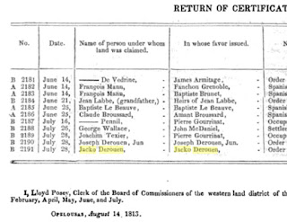 |
| Page detail from the American State Papers (1834) re: Jacko Derouen’s land in 1813. (Source: Google Books) |
Unfortunately, I know little about Jacko Derouen himself.
It does seem a little odd that a prairie should bear the first name of a local settler, rather than their surname. This is, however, not the only such instance of this practice. Barthélémy Lafon’s 1806 map of Louisiana, titled Carte générale du territoire d’Orléans comprenant aussi la Floride Occidentale et une portion du territoire du Mississipi, identifies the two salt domes now called Avery Island and Weeks Island as the "Cotes à Judith" (which I would translate as "Hills [Côtes] of Judith" or "Judith’s Hills"). As with "Jacko," I assume "Judith" is a first name.
Regardless, I have never been able to identify the namesake for "Cotes à Judith," and I now wonder if Lafon did not merely garble the surname "Judice." That surname was present in south Louisiana by the 1730s and today is fairly common in the region. Indeed, this solution seems even likelier when one considers that in French, more so than in English, "Judith" sounds remarkably like "Judice."
No doubt there is more out there to be found about these two south Louisiana toponyms.
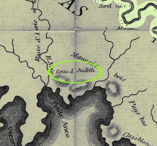 |
| The "Côtes à Judith" from Lafon's 1806 map; Bayou Teche shown at upper right. (Source: Library of Congress) |


.png)

