Showing posts with label Thomas Hutchins. Show all posts

Thursday, February 10, 2022

"Prairie de Jacko": Source of the Name?

I recently noticed an old Louisiana land document for sale on eBay. It concerned property located near the confluence of Bayou Teche and the Atchafalaya River. (What is called Bayou Teche on this map is today called the Lower Atchafalaya, the Teche now regarded as flowing into the Lower Atchafalaya at Patterson.)
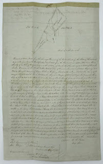
The old Louisiana land document.
(Source: eBay.com)

In other words, the document concerns land near the present-day community of Baldwin, across the Atchafalaya River from present-day Morgan City. 

Note the document’s hand-drawn map. Written across parcels spanning both "Bayou Teche" and the Atchafalaya is the name "Jacko Derouen." (Yes, Jacko, as in Michael Jackson’s nickname — though I expect the south Louisiana "Jacko" would have pronounced his name the French way: ZHAH-KO.) Jacko Derouen’s full name also appears below the map, in the actual text of the document.
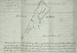
Close-up of the hand-drawn map.
(Source: eBay.com)

I believe this document answers a question of mine I’ve had for some years: Why in the 1700s was an expanse of land in that region called "Prairie de Jacko"?

From my previous research I knew the toponym appeared in Thomas Hutchins’ 1784 book An Historical Narrative and Topographical Description of Louisiana and West-Florida. In that work Hutchins stated "3 miles below the Tage [Teche] river on the western side is a large savanna known by the name of Prairu de Jacko [Prairie de Jacko]. From this savanna is about 33 miles to the sea."

Page detail from Hutchins' 
An Historical Narrative (1784).
(Source: University of Florida)

Another reference appears on Hutchins’ presumably earlier hand-drawn map of the Teche region. Found not in a Louisiana archives, but in the holdings of the Historical Society of Pennsylvania in Philadelphia, that map — which I believe Hutchins drew between 1779 and 1784 — shows the scrawled placename "Prari[e] de Jacob."

Hutchin's upside-down map (detail).
(Source: Historical Society of Pennsylvania)

The name also appears in the 1779 journal of François Gonsoulin, who, though French in origin, served in Louisiana as a Spanish royal surveyor (the colony having passed from France to Spain in 1762-63). The Spanish government had tasked Gonsoulin, along with local Flemish settler Jean-Baptiste Grevemberg and several enslaved rowers, with exploring the course of the middle and lower Bayou Teche. They would travel downstream from newly founded New Iberia (then called Nueva Iberia) to the bayou’s mouth — a stretch that not only included the present-day Teche below New Iberia, but the waterways now considered the Lower Atchafalaya and the Atchafalaya itself. Even then this was a matter of contention. As I wrote in my 2016 book Teche: A History of Louisiana’s Most Famous Bayou (University Press of Mississippi): 

Indeed, he [Gonsoulin] bristled at those like [colonial leader] Bouligny who called the Lower Atchafalaya "el Rio Grande" or in French "Grand Rivière." They spoke "inappropriately," asserted Gonsoulin in his diary. On the contrary, the great river, he insisted, was "always the Teche."

In my Teche book I also included the below passage about Gonsoulin’s 1779 exploration of the bayou and its distributaries: 

The falua [a type of boat] passed a flat grasslands, which Gonsoulin identified as "la Prairie à Jacob," or Jacob’s Prairie. (This is the same stretch Hutchins had called the Prairie de Jacko and the Prairie de Jacob.) 

Cover of my book Teche.

I assume the "Jacko" or "Jacob" mentioned by these early sources is none other than Jacko Derouen. This seems likely, given the peculiarity of the name Jacko: unlike the surname Derouen (commonly found in present-day south Louisiana), the "prénom" Jacko certainly strikes me as unusual, perhaps even unique, for the time and place in question. It could, however, be a diminutive, a corruption, or simply a misspelling of the common name "Jacob" — as the name is indeed rendered by Gonsoulin — or its French equivalent "Jacques." (There is indeed a Jacques Derouen mentioned in early 19th-century historical documents pertaining to south Louisiana.)
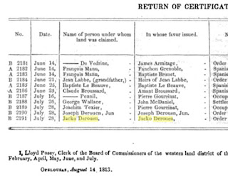
Page detail from
the American State Papers (1834)
re: Jacko Derouen’s land in 1813.
(Source: Google Books)

Unfortunately, I know little about Jacko Derouen himself. 

It does seem a little odd that a prairie should bear the first name of a local settler, rather than their surname. This is, however, not the only such instance of this practice. Barthélémy Lafon’s 1806 map of Louisiana, titled Carte générale du territoire d’Orléans comprenant aussi la Floride Occidentale et une portion du territoire du Mississipi, identifies the two salt domes now called Avery Island and Weeks Island as the "Cotes à Judith" (which I would translate as "Hills [Côtes] of Judith" or "Judith’s Hills"). As with "Jacko," I assume "Judith" is a first name.

Regardless, I have never been able to identify the namesake for "Cotes à Judith," and I now wonder if Lafon did not merely garble the surname "Judice." That surname was present in south Louisiana by the 1730s and today is fairly common in the region. Indeed, this solution seems even likelier when one considers that in French, more so than in English, "Judith" sounds remarkably like "Judice."

No doubt there is more out there to be found about these two south Louisiana toponyms.
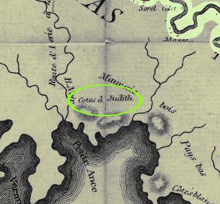
The "Côtes à Judith"
from Lafon's 1806 map;
Bayou Teche shown at upper right.
(Source: Library of Congress)


Thursday, December 1, 2011

La Chute: A Waterfall on Bayou Teche?

I became aware of claims that a waterfall once emptied into Bayou Teche while examining one of the first extremely accurate maps of Louisiana — Barthélémy Lafon’s "Carte générale du territoire d’Orléans," printed in New Orleans in 1806. On the Teche above New Iberia, and a little upstream from the site of present-day Loreauville, Lafon printed in minuscule type the word "chûtte."

The "chûtte" as shown on Barthélémy Lafon’s
"Carte générale du territoire d’Orléans" (1806).
I've labeled the present-day sites of New Iberia,
Loreauville, and Spanish Lake.
(Source: Library of Congress)

In French chute means "waterfall."

A waterfall on the Teche?  In flat coastal south Louisiana?

Later I examined a report on Bayou Teche by former British soldier and spy (and, after switching sides during the American Revolution, official geographer to the fledgling United States) Thomas Hutchins. He had gathered intelligence on the bayou from circa 1772-1784, when Spain, a major rival to the British in nearby West Florida, held much of present-day Louisiana, including the Teche country.


Title page of Hutchins' 1784 book containing
his report on Bayou Teche.

As Hutchins guided his reader up the Teche, he observed:
About 3 leagues above la Nouvelle Iberia [New Iberia] is la Force Point [Fausse Pointe]. . . . Then to la Shute branch, which passes over a fall of about 10 feet, near to where it enters the Tage [Teche] river, it is 3 leagues. . . .
Moreover, Hutchins prepared a hand-drawn map of the Teche, which shows the approximate location of the fall or “shute” (or “shout” as he spells it on the map).

Detail of Hutchins' ca. 1780 map of Bayou Teche
showing the "Shout" (chute).  I've labeled New Iberia,
the present-day site of Loreauville, and the Teche itself.
(Source: Author's collection.)


That Lafon and Hutchins both mention the chute and show it at roughly the same location may not, however, be evidence of corroboration. I increasingly believe that Lafon used Hutchins’ report as a source in making his map. (Hutchins’ report and Lafon’s map share a few idiosyncrasies; moreover, Hutchins’ report had been published in 1784 and would have been available to Lafon.)

Enter fellow researcher Don Arceneaux, a native south Louisianian and trained biologist who works in the forests of the northwestern U.S. Don had been looking into the history of the Attakapas region and, as I had, noticed the one or two known references to the chute. But he also found another chute reference, namely, in an early-nineteenth-century land record mentioned in Glenn R. Conrad’s Land Records of the Attakapas District. That land record refers to the chute as sitting on the property of a specific landowner — which allowed Don to pin down more precisely the chute’s location.

In fact, Don believes that modern topographical maps and aerial photographs show the remnant of the chute. And that assumed remnant sits right in the area where the Hutchins, Lafon, and Conrad references said the chute had been located over two centuries ago. The feature in question is no longer a waterfall, its dirt or clay drop (no rock in south Louisiana!) having eroded away or having been removed by human activity. Rather, it is a coulee (our local word for creek) flowing into the Teche from two main branches, one coming from the direction of Spanish Lake to the west and another coming from the neck of land formed by a meander in the Teche near Loreauville.


Topographical map showing the assumed site
of the chute (coulee at middle flowing north into the Teche).  (Source: TopoZone.com)

Don theorizes that in the eighteenth century the Teche’s natural levee acted like a dam, turning this jutting neck of land into a bowl that flooded with rainwater during the region’s semitropical downpours. The water found its way through a narrow gap in the levee, and it was there that the chute poured into the Teche.

Interestingly, the word “chute” describes a particular kind of waterfall. According to James R. Penn’s Rivers of the World: A Social, Geographical, and Environmental Sourcebook (2001), a chute is "[a] ‘shortcut’ across a meander bend” or “any narrowing of a channel through which water velocity increases. In this way, water confined by protruding rocks in waterfalls or rapids produces chutes." While it is possible that the chute on the Teche was merely "[a] ‘shortcut’ across a meander bend" (since the assumed spot is indeed on a meander in the Teche), Hutchins, however, recorded that the chute had "a fall of about 10 feet," indicating clearly that it was a waterfall.

Penn is concerned with the modern definition of chute, but what did the word mean in the eighteenth-century?  Chute in French literally meant "fall" (as it still does today) and could be used in reference to any number of things. For example, "la chute de l’empire romain" — "the fall of the Roman Empire." But in a hydrographic sense, chute — used primarily in French at the time — did in fact denote a waterfall. In The Royal Dictionary (1773), for example, the English waterfall is translated into French as chute d’eau. Likewise, Le grand dictionnaire géographique, historique et critique (1768) observes, "Waterfall, dans la langue du pays, signifie chute d’eau." ("Waterfall, in the language of the land, signifies chute d’eau.")


Aerial photograph showing assumed site of the chute.
Click image to enlarge. (Source: Google Maps)

Hutchins, by original training a surveyor and cartographer, had explored the former French territories of Illinois and Ohio.  As such, he might have known the word chute before traveling to the Gulf Coast around 1772. Along with the word’s local use by francophone Acadians and French Creoles, Hutchins prior knowledge of the term would explain his use of “shute” in his report and on his bilingual (English and French) map of the Teche.

At this point Don and I cannot say for certain that the present-day coulee flowing into the Teche near Loreauville is the remnant of the eighteenth-century chute. But this modern geographic feature seems to us the only clear candidate for the chute.

Don has recently examined the area by kayak, and I plan to go there shortly by canoe.

Addendum (of 1 December 2011):

I think we just solved the puzzle!  While examining a digitized U.S. Geological Survey map, I noticed that the USGS provided a name for the present-day coulee that Don has suggested as the chute’s former location.  And what does the USGS call the present-day coulee?  "Bayou La Chute"!


Screen shot showing the identification of the assumed site
of the chute as "Bayou La Chute" (Source: TopoZone.com)

Can you imagine that?  The memory of an over two-hundred-year-old waterfall preserved in the name of a present-day waterway on the same spot!

I think this pretty much closes the case in Don's favor!

Addendum (of 4 December 2011):

Yesterday I canoed to the site of the chute with Keith Guidry and Don Arceneaux.  Don had already been to the site six days earlier, but Keith and I had never been there.  Actually, Keith had canoed passed it previously, but didn't know its significance at the time.


The entrance to Bayou La Chute and the location
(or approximate location) of the eighteenth-century
waterfall known as "the chute."
(Photo by the author)


What we saw at the site of the chute was the entrance to a small bayou [30.03667, -91.786284], about thirty-five feet wide at its mouth, running through a deep cut in the natural ridge that follows the Teche.  The banks at this spot are higher than any others I've seen along the Teche, rising about eight to ten feet above the water on the left side of the cut and about three to five feet on the right.  A prominent grassy hill or ridge tops the bluff on the right, rising perhaps another twenty-five to thirty feet above the surface of the Teche.  One can imagine a chute here two hundred years ago, spilling into the Teche over a drop that at the time connected the high lands to either side of the waterfall.

Heading upstream on Bayou La Chute.
Note the cypress trees and cypress knees
(and someone's fishing chair) on the left bank.
(Photo by the author)


As mentioned, there is no waterfall at the site today, the drop having eroded away or having been cleared by human activity.  As such, one can now canoe directly into the chute's remnant, a waterway called Bayou La Chute, and navigate a fair distance up it and its tributaries.  Kevin, Don, and I followed Bayou La Chute for about a quarter mile upstream from the Teche, stopping — though the depth of the water would have permitted us to go farther — only when we reached the fork where the bayou's tributaries turned east onto the neck of the Teche meander and west toward Spanish Lake.


Fork in Bayou La Chute, one heading east (left) onto the neck
of the Teche meander and one heading right (west) toward Spanish Lake.
(Photo by the author)


Although there is a small amount of garbage, an occasional drainage pipe, and some non-indigenous ornamental bamboo along its banks, Bayou La Chute is otherwise wild in appearance, very beautiful, and well worth diverting from the Teche for a side trip up its narrow, winding course.

Addendum (of 7 December 2011):

As lagniappe here is a detail of an 1846 plat map for the area T12S R7E (just below the Teche) showing the bayou in question as "Bayou La Chute."  Its intersection with the Teche does not appear because that feature lies slightly to the north in the next township (T11S R7E).


(Source: Office Of Public Works Plat Map
for District Southwestern T12S R7E [1846],
Louisiana Office of State Lands)


Even better: below is an 1850 copy of a 1795 French-language map of the same area, showing "la chute" as lying on the property of Monsieur Claire Dauterive Dubuclé (Dubuclet) — something Don Arceneaux pointed out to me a couple weeks ago in Conrad's land records book.  I only found the below map today, however, in the Louisiana Office of State Lands.  (Thanks to Michael Marie for telling me how to search the office's records!)  Interestingly, the surveyor who made the original 1795 map was none other than François Gonsoulin, whom I mention in a couple of previous blog articles.  By the way, the below map is oriented so that north is to the lower left.  (In other words, the map is more or less upside down.)

Map showing "la chute" near the "Rivière Thex" (Teche). Click to enlarge.
 (Source: Claim Papers S.W.D. T12S R3-7E, Vol. 24,
Louisiana Office of State Lands [1850 copy of 1795 original])