Showing posts with label Teche. Show all posts

Thursday, February 10, 2022

"Prairie de Jacko": Source of the Name?

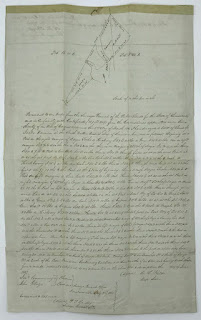
I recently noticed an old Louisiana land document for sale on eBay. It concerned property located near the confluence of Bayou Teche and the Atchafalaya River. (What is called Bayou Teche on this map is today called the Lower Atchafalaya, the Teche now regarded as flowing into the Lower Atchafalaya at Patterson.)

The old Louisiana land document.
(Source: eBay.com)

In other words, the document concerns land near the present-day community of Baldwin, across the Atchafalaya River from present-day Morgan City. 

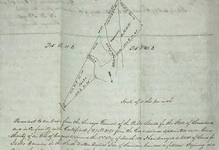
Note the document’s hand-drawn map. Written across parcels spanning both "Bayou Teche" and the Atchafalaya is the name "Jacko Derouen." (Yes, Jacko, as in Michael Jackson’s nickname — though I expect the south Louisiana "Jacko" would have pronounced his name the French way: ZHAH-KO.) Jacko Derouen’s full name also appears below the map, in the actual text of the document.

Close-up of the hand-drawn map.
(Source: eBay.com)

I believe this document answers a question of mine I’ve had for some years: Why in the 1700s was an expanse of land in that region called "Prairie de Jacko"?

From my previous research I knew the toponym appeared in Thomas Hutchins’ 1784 book An Historical Narrative and Topographical Description of Louisiana and West-Florida. In that work Hutchins stated "3 miles below the Tage [Teche] river on the western side is a large savanna known by the name of Prairu de Jacko [Prairie de Jacko]. From this savanna is about 33 miles to the sea."

Page detail from Hutchins' 
An Historical Narrative (1784).
(Source: University of Florida)

Another reference appears on Hutchins’ presumably earlier hand-drawn map of the Teche region. Found not in a Louisiana archives, but in the holdings of the Historical Society of Pennsylvania in Philadelphia, that map — which I believe Hutchins drew between 1779 and 1784 — shows the scrawled placename "Prari[e] de Jacob."

Hutchin's upside-down map (detail).
(Source: Historical Society of Pennsylvania)

The name also appears in the 1779 journal of François Gonsoulin, who, though French in origin, served in Louisiana as a Spanish royal surveyor (the colony having passed from France to Spain in 1762-63). The Spanish government had tasked Gonsoulin, along with local Flemish settler Jean-Baptiste Grevemberg and several enslaved rowers, with exploring the course of the middle and lower Bayou Teche. They would travel downstream from newly founded New Iberia (then called Nueva Iberia) to the bayou’s mouth — a stretch that not only included the present-day Teche below New Iberia, but the waterways now considered the Lower Atchafalaya and the Atchafalaya itself. Even then this was a matter of contention. As I wrote in my 2016 book Teche: A History of Louisiana’s Most Famous Bayou (University Press of Mississippi): 

Indeed, he [Gonsoulin] bristled at those like [colonial leader] Bouligny who called the Lower Atchafalaya "el Rio Grande" or in French "Grand Rivière." They spoke "inappropriately," asserted Gonsoulin in his diary. On the contrary, the great river, he insisted, was "always the Teche."

In my Teche book I also included the below passage about Gonsoulin’s 1779 exploration of the bayou and its distributaries: 

The falua [a type of boat] passed a flat grasslands, which Gonsoulin identified as "la Prairie à Jacob," or Jacob’s Prairie. (This is the same stretch Hutchins had called the Prairie de Jacko and the Prairie de Jacob.) 

Cover of my book Teche.

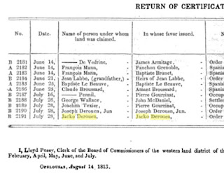
I assume the "Jacko" or "Jacob" mentioned by these early sources is none other than Jacko Derouen. This seems likely, given the peculiarity of the name Jacko: unlike the surname Derouen (commonly found in present-day south Louisiana), the "prénom" Jacko certainly strikes me as unusual, perhaps even unique, for the time and place in question. It could, however, be a diminutive, a corruption, or simply a misspelling of the common name "Jacob" — as the name is indeed rendered by Gonsoulin — or its French equivalent "Jacques." (There is indeed a Jacques Derouen mentioned in early 19th-century historical documents pertaining to south Louisiana.)

Page detail from
the American State Papers (1834)
re: Jacko Derouen’s land in 1813.
(Source: Google Books)

Unfortunately, I know little about Jacko Derouen himself. 

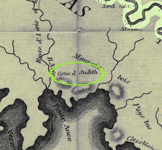
It does seem a little odd that a prairie should bear the first name of a local settler, rather than their surname. This is, however, not the only such instance of this practice. Barthélémy Lafon’s 1806 map of Louisiana, titled Carte générale du territoire d’Orléans comprenant aussi la Floride Occidentale et une portion du territoire du Mississipi, identifies the two salt domes now called Avery Island and Weeks Island as the "Cotes à Judith" (which I would translate as "Hills [Côtes] of Judith" or "Judith’s Hills"). As with "Jacko," I assume "Judith" is a first name.

Regardless, I have never been able to identify the namesake for "Cotes à Judith," and I now wonder if Lafon did not merely garble the surname "Judice." That surname was present in south Louisiana by the 1730s and today is fairly common in the region. Indeed, this solution seems even likelier when one considers that in French, more so than in English, "Judith" sounds remarkably like "Judice."

No doubt there is more out there to be found about these two south Louisiana toponyms.

The "Côtes à Judith"
from Lafon's 1806 map;
Bayou Teche shown at upper right.
(Source: Library of Congress)


Sunday, June 5, 2016

Now Available: My New Book about Bayou Teche


Teche: A History of Louisiana's Most Famous Bayou

My newest book, Teche: A History of Louisiana's Most Famous Bayou, has been released by my publisher, University Press of Mississippi. (To order the book from Amazon.com, click here. It's also available from all other booksellers, including local independent booksellers.)


Cover art for my new book.
The painting is by noted south Louisiana
artist Melissa Bonin.

As the book's description reads: 

Shane K. Bernard’s Teche examines this legendary waterway of the American Deep South. Bernard delves into the bayou’s geologic formation as a vestige of the Mississippi and Red Rivers, its prehistoric Native American occupation, and its colonial settlement by French, Spanish, and, eventually, Anglo-American pioneers. He surveys the coming of indigo, cotton, and sugar; steam-powered sugar mills and riverboats; and the brutal institution of slavery. He also examines the impact of the Civil War on the Teche, depicting the running battles up and down the bayou and the sporadic gunboat duels, when ironclads clashed in the narrow confines of the dark, sluggish river.


Image from the (New York) Weekly Graphic (18 April 1874).
Author's Collection.

Describing the misery of the postbellum era, Bernard reveals how epic floods, yellow fever, racial violence, and widespread poverty disrupted the lives of those who resided under the sprawling, moss-draped live oaks lining the Teche’s banks. Further, he chronicles the slow decline of the bayou, as the coming of the railroad, automobiles, and highways reduced its value as a means of travel. Finally, he considers modern efforts to redesign the Teche using dams, locks, levees, and other water-control measures. He examines the recent push to clean and revitalize the bayou after years of desecration by litter, pollutants, and invasive species. Illustrated with historic images and numerous maps, this book will be required reading for anyone seeking the colorful history of Louisiana and the Gulf Coast.


The author (right) canoeing on Bayou Teche.
(Click to enlarge.)

As a bonus, the second part of the book describes Bernard’s own canoe journey down the Teche’s 125-mile course. This modern personal account from the field reveals the current state of the bayou and the remarkable people who still live along its banks.

Thursday, May 9, 2013

"Cajuns of the Teche": Bad History, Wartime Propaganda, or Both?

I first learned about the short film Cajuns of the Teche, directed by André de LaVarre and released in August 1942 by Columbia Pictures, while researching my book The Cajuns: Americanization of a PeopleThis find occurred by accident in the late 1990s, while looking for something else in the National Archives and Records Administration. (Serendipity often happens when I’m conducting historical research. I think it’s a perfectly valid form of discovery.)

Title cards from Cajuns of the Teche.
(Screen grabs by author)

In short, a reel of film labeled Cajuns of the Teche sat in the National Archives and had not yet been dubbed to videotape (much less had it been digitized; that technology was not yet at hand for most people). A student at the time, I didn’t have the $250 or so that the National Archives wanted to transfer the film to video, so I contacted my friend, Lafayette attorney Warren A. Perrin. Back then Warren served as president of the Council for the Development of French in Louisiana and owned, as he still does, the Acadian Museum in his hometown of Erath.

Warren agreed to fund the film’s transfer to video through his museum, so I filled out the pertinent paperwork, mailed it off, waited, and a few weeks later a VHS dub arrived from Washington, D.C. I watched the film, found it delightful, but ultimately did not use it as research material for my book. Moving on to other projects, I forgot about the dub for about fifteen years, but recently pulled it out of my files and digitized it so that I can present it here:

(Click to play video)

Two thoughts come to mind when I watch Cajuns of the Teche: First, after seventy years the images are crisp, clear, well-composed, and in my opinion extremely valuable as a record of the Teche region around World War II; second, the narration is often extremely misleading and in some instances downright wrong. 

I’ll catalog these misleading and incorrect claims. The narrator repeatedly refers to the Cajuns’ ancestors as “Arcadians,” when the proper term is “Acadian.” Moreover, the Acadians did not arrive in Louisiana when it was “a colony of the kingdom of France,” as the narrator asserts, but a colony of Spain (albeit one administered for a time by French caretakers — Spain only slowly assumed full control of the formerly French colony).

The scenes of grandiose “Cajun homes” (see timestamps 3:19, 4:45 and 5:13 to 5:21 on the video) never fail to elicit snickers from other Cajuns to whom I’ve shown the film privately. The narration is entirely misleading when it states, “In the past we built many grand and spacious mansions, for our families were large and our attendants were many.” The dwellings in the film were far too luxurious for average, ordinary Cajuns, most of whom lived as subsistence farmers — and who certainly did not have many “attendants” (apparently a euphemism for “slaves”). Granted, a very few “genteel Acadians” managed to rise to positions of wealth in antebellum south Louisiana — mainly sugar planters with enslaved workforces — but they were the exception, not the rule.

Not a Cajun house.
(Screen grab by author)

In addition, the narration refers to the Louisiana colony as “a land with freedom of religion.” While it is true that the Acadians freely practiced their Catholic faith in Spanish-held Louisiana — the Spanish, after all, were Catholics, too — the colony was hardly a bastion of religious toleration. The Spanish, for example, forbid Protestants from holding public worship and they expelled all Jews from the colony.

The “Cajun garden” shown in the film at 5:27 — featuring a centuries-old Buddha statue, if one looks closely enough — is actually Jungle Gardens, owned and operated by Scots-Irish Tabasco sauce manufacturer E. A. McIlhenny (hardly a Cajun).

Some of the narration is drivel. I do not believe, as claimed at 9:47 in the film, that an appreciation of “fine silks and soft satins” represented “one of the strongest traits of French heritage” among Cajun girls. Equally nonsensical is the narrator’s reference at 5:55 — made over the image of fancifully dressed Cajun men and girls enjoying an elegant ring dance — to “slippered steps of old Acadia.” Acadian men and woman alike generally wore moccasins, living as they did on the rugged North American frontier. 

Historically inaccurate Norman milkmaid costume.
(Screen grab by author)

Fortunately, the images themselves are infinitely more valuable than the narration. This is not to say that some of the images are not misleading. For example, the Norman milkmaid costumes worn in the film by some Cajun girls and women (0:45 and 8:05) were unknown to their Acadian ancestors. An example of what anthropologists and other scholars call “fakelore,” these costumes were probably introduced to more upwardly mobile Cajuns through mass-produced, illustrated volumes of Longfellow’s epic poem Evangeline (which follows the fate of an Acadian maiden exiled to south Louisiana). I say “upwardly mobile” because the mass of ordinary Cajuns never read Evangeline.

Circa 1890 depiction of Evangeline.
(Colorized by author)

Criticism aside (at last, you say), I made these other observations while watching Cajuns of the Teche:

The shot of boats moored along a bayou (1:43) seems to show some other waterway besides the Teche, perhaps Bayou Lafourche. I could be wrong — perhaps it is the Teche.

The stern-wheeler shown early in the film (1:50), the V. J. Kurzweg, is despite its appearance not a steamboat. As Carl A. Brasseaux writes in Steamboats on Louisiana’s Bayous, the Kurzweg “is widely — albeit inaccurately — remembered along Bayou Teche as one of the stream’s last steamboats,” but it “was not technically a steamboat” because “it was propelled by diesel motors.” Note the Kurzweg has no towering twin smokestacks as found on most steamboats: as a diesel-powered vessel it did not require them.

The V. J. Kurzweg on Bayou Teche, ca. 1942.
(Screen grab by author)

The fishermen at 2:35 do not seem to be on Bayou Teche, but rather in a cypress swamp. (A bayou is a slow-moving, muddy, usually smallish river, while a swamp is a wooded wetland.) If I had to guess, I would say the swamp in question is the Atchafalaya, if only because of its proximity to the Teche. But there are many patches of swamp in the region that are not in the Atchafalaya. In any event, the swamp in the film was clearly experiencing a flood, as indicated by the swift current.

Sugar cane field workers in Cajuns of the Teche.
(Screen grab by author)

Another scene depicts a mounted white overseer (3:55) supervising a work crew as it weeds young sugarcane shoots. I cannot tell if the work crew is black or white or both. A shot of three male field workers reveals one with black hands (also 3:55), but work gloves mask the race of the other two workers. A wide shot appears to show two white female field workers at far left (4:13). The other field workers in the shot, however, cannot be seen clearly enough to establish their races.

It is tempting to draw a lesson about race or race relations from this scene. But it is impossible to do so without really knowing the workers’ racial makeup. Regardless, the shot does illustrate the region’s dependence on manual field labor in 1942. It would take the ongoing war and resulting labor shortages to spur south Louisiana agriculture to mechanize. What I observed about rural Lafayette Parish in The Cajuns no doubt held true for much of Cajun Louisiana: Despite the findings of a 1942 survey “that ‘tractors are not thought to be necessary or even desirable,’” Lafayette parish farmers “had almost universally adopted mechanization within a decade. ‘The old days of the plow and the horse are gone,’ observed a 1951 survey.”

A ring dance on the banks of the Teche.
(Screen grab by author)

The reference to “giant spiders” (4:09) alludes to the legend of the Durand wedding, which allegedly occurred at Oak and Pine Alley on the outskirts of St. Martinville. As journalist Jim Bradshaw records:
It was only to be expected that [Durand] would throw the finest wedding ever when two of his daughters decided to get married on the same day. . . . [A]s the romantic legend is told, he ordered a million spiders sent from China and sent couriers to California to fetch hundreds of pounds of silver and gold dust. (A less romantic version of the story says the spiders came from nearby Catahoula Lake, but I like the China version better.) . . . Shortly before the wedding day, the spiders were set loose to spin millions of yards of delicate webs among the limbs of the oak and pine alley. On the morning of the wedding, servants armed with bellows filled with the silver and gold dust sprayed the cobweb canopy to set it glittering in the sunlight like something from a fairy tale.
Of this legend Brasseaux states, “Most southern Louisianians are familiar with the stories of the spiders imported from China for the Oak and Pine Alley wedding.” Yet it along with similar local legends, he notes, have been “proven unfounded by recent historical research.” (To Bradshaw’s credit, he concurs with Brasseaux that the story is a legend.)

Elsewhere, the narrator observes (6:08) “We Cajuns speak French among ourselves, and some of our children do not learn English until they reach the classroom.” Where they will have the French whipped out of them, I thought. I was being only slightly facetious, for south Louisiana educators often punished Cajun children for speaking French at school. More than any other factor, this practice accounted for the rapid decline of Cajun French during the early to mid-twentieth century. (See my previous blog article about tracking this decline.)

Quilters with garde-soleils.
(Screen grab by author)

Finally, although the Cajuns’ dress is not “authentic” (that is, historically accurate) in the spinning wheel scene at the beginning or in the ring dance scene, the clothing shown in other scenes does strike me as authentic.  See, for example, the field workers (Cajun or otherwise) shown from 3:55 to 4:29; and the school children from 6:05 to 6:24. (Note the students in question attended an all-white school: segregation did not end in much of Louisiana until 1969 — about fifteen years after the U.S. Supreme Court case Brown v. Board of Education struck down separate-but-equal schooling nationwide.) See also the churchgoers at 6:38 and 6:45; the corn husk weavers at 7:05; and the quilters at 7:42 (complete with their garde-soleils, or sunbonnets). In addition, see the weaver at right, but not at left, at 8:04, and, conversely, the same weaver at left, but not at right, at 8:10; and the wedding goers at the end of the film (9:40 onwards). The apparel in these scenes looks very authentic to me. Perhaps the subjects had no time or compulsion to dress for the camera?

Horse and buggies leaving Cajun wedding.
(Screen grab by author)

Now to address an issue other than the film’s accuracy: Was the film wartime propaganda?

I found Cajuns of the Teche in the National Archives collection of the U.S. Information Agency (USIA). Founded in 1953 during the Cold War and still active today, the USIA, as its website notes, “explains and supports American foreign policy and promotes U.S. national interests through a wide range of overseas information programs . . . [and] promotes mutual understanding between the United States and other nations by conducting educational and cultural activities.” Created prior to the advent of the USIA, Cajuns of the Teche sat in a section of the USIA collection regarding an earlier organization, the U.S. Office of War Information (OWI). Established in 1942, the OWI, as the Library of Congress explains, “served as an important U.S. government propaganda agency during World War II.”

Logos of the USIA and the OWI.

Why would a travelogue film issued by Columbia Pictures be found in a collection pertaining to the OWI?

The answer might be found in a pictorial “feature” (pre-packaged photo essay for overseas consumption) issued by the OWI in 1944 and titled “The Bayou French of Louisiana.” This feature consisted of a four-page typewritten essay about the Cajuns along with many captioned black-and-white still images. These photos depicted “everyday” Cajun culture, activities, and places. 

Intriguingly, at least four of these black-and-white still images depict events also shown in Cajuns of the Teche. Moreover, these black-and-white images were clearly shot at the exact same moment as the corresponding images in the film — albeit from slightly different angles. See the below image comparisons: Those at left are “screen grabs” from Columbia Pictures’ Cajuns of the Teche, while those at right are still images from the OWI's “The Bayou French of Louisiana.” As you can see, the paired images are almost identical (click to enlarge):


The OWI’s “The Bayou French of Louisiana” was clearly wartime propaganda. Its purpose was to show overseas audiences how American society could support an ethnically heterogeneous population, yet still be undeniably “American.” As the OWI essay accompanying the images put it, “The persistence of Cajun French traditions in the United States, as those of other national groups, is encouraged in the belief that such diversity enriches and strengthens democratic institutions. The various population groups of the United States are encouraged to perpetuate their folkways so that each may contribute to the homogenous but broadly variegated culture of the United States.”

But was the earlier Cajuns of the Teche also wartime propaganda? 

The federal government created the U.S. Office of War Information in June 1942; Columbia Pictures issued Cajuns of the Teche the next month. This would hardly seem enough time for the fledgling OWI to produce an eleven-minute film shot on location in south Louisiana and to arrange for a major Hollywood studio to distribute it. And while there are examples of the OWI and Columbia Pictures teaming up later to release wartime propaganda films (such as the 1943 film Troop Train and the 1945 film The True Glory), there is no known evidence of OWI involvement with Cajuns of the Teche.

Back of OWI print indicating when and
from whom it had been purchased.
(National Archives and Records Administration,
Washington, D.C.)

A key to understanding the actual, tenuous relationship between the OWI’s propagandistic “The Bayou French of Louisiana” and Columbia Pictures’ Cajuns of the Teche may be found on the back of the original B&W prints used with “The Bayou French of Louisiana.” Data there indicates that the OWI licensed the images from a commercial entity named “Screen Traveler, from Gendreau.” Presumably a stock photo vendor, Screen Traveler may have sent a photographer to Louisiana in 1942 alongside Columbia Pictures’ film crew. This would explain why some of the images in Cajuns of the Teche and some of those in “The Bayou French of Louisiana” correspond so closely.

Ultimately, I do not believe — given the current evidence — that Cajuns of the Teche was a product of OWI wartime propaganda; but I do believe that still photographs taken during the filming of Cajuns of the Teche ended up in the wartime propaganda project “The Bayou French of Louisiana.” I make this assertion because we know for certain that the OWI, a government entity charged with producing wartime propaganda, issued “The Bayou French of Louisiana”; and we know that some of the images used in “The Bayou French of Louisiana” closely match scenes in Cajuns of the Teche.

Still, the question remains: why is there a reel of Cajuns of the Teche in the OWI section of the USIA's archival collection?


Sunday, October 7, 2012

Sur le Teche: Exploring the Bayou by Canoe, Stage 1

To research my history of Bayou Teche I resolved to paddle the entire length of the waterway.  Friends found this humorous because they knew me to be an “avid indoorsman.”  But how could I not paddle it?  Had I not paddled it, someone, somewhere — at a book signing, during an interview — would inevitably ask me, “Have you ever been on Bayou Teche?” to which I would have had to answer, “No — but I drive across it every day on the way to work.”

The paddlers for stage one, at the Courtableau landing.
Back row: Jacques, Preston, and me; in front, Keith.
(Click images to enlarge them; photograph by author)

So I decided to explore the entire bayou and to do so not by motorboat (which seemed like cheating), but the old-fashioned way, by canoe — all approximately one hundred twenty-five miles of it.  It just seemed the thorough thing to do, if I were going to write a book about the Teche.  And this proved correct, because there was no substitute for seeing for oneself, from a canoe, where the Teche springs from Bayou Courtableau, meets Bayou Fuselier, zigzags at Baldwin, juts out at Irish Bend.

I would not canoe the bayou all at once, however, but in stages over many months.  And I would do so slowly, stopping to take ample notes, photographs, GPS coordinates.  This journal is based on that data.


Preston and Jacques heading into the Teche from the Courtableau.
(Photograph by author)

I drafted two friends to assist me in the trek, both recent archaeology graduates from University of Louisiana at Lafayette: Preston Guidry and Jacques Doucet.  Preston’s father, Keith Guidry, made up a last-minute addition to the team.  And while Preston and Jacques ended up sitting out several stages of the trip, Keith became my one constant: we, the two older guys in our forties and fifties, would be the only two members of the canoe team to complete the entire journey.

Ben Guidry filled in for brother Preston on a couple stages; and my fellow history enthusiast Don Arceneaux joined Keith and me for one stage.

I was the least experienced paddler of the group, but the others made up for my greenness. Together, an Arceneaux, a Doucet, three Guidrys, and a Bernard, we would seek an answer to the weighty question, “How many Cajuns does it take to paddle Bayou Teche?”


Aerial photograph of Stage 1, Port Barre to Arnaudville.
(Source: Google Maps)

Stage 1: Port Barre to Arnaudville

We began our trip around 9 a.m. on October 23, 2011.  The temperature that morning was cool (about 56 °F), but grew warmer in the afternoon (about 81 °F).  The sky was mostly clear.  We chose that day to start our trip because it fell shortly after the annual Tour du Teche canoe race. We didn’t want to get in the way of the racers and so let them go first.  Preston, Jacques, Keith and I put in at the public boat ramp at Port Barre [30.558367, -91.954874], on Bayou Courtableau.  Port Barre — the town whose speed trap the swamp pop band Rufus Jagneaux sang about in the early 1970s:

All of y’all know about Port Barre.
(If ) they catch you there it’s half of your hide.
You might as well gone to Tucumcari.
It costs you that to leave there alive.

In all fairness to Port Barre, the song was actually written about a speed trap in nearby Krotz Springs; but “Port Barre” just sounded more lyrical to the composer.

It was in Port Barre that the Courtableau Inn, a nightclub owned by my great-grandfather, Oscar Bordelon — first name pronounced OH-SCARE in the French manner — stood right across the bayou from the boat ramp.  In fact, it stood on the lot now occupied by the Squeaky Clean Car/Boat Wash.  It was there, in that nightclub in the late 1940s and early ‘50s, that my father heard Cajun musicians like Papa Cairo and Nathan Abshire.  Dad recalls slot machines lining the walls, even though the devices were illegal at the time.  But those were the days of legendary St. Landry Parish sheriff “Cat” Doucet, who tolerated gambling and certain other prohibited vices.


My great-grandfather's nightclub;
at far right you can see Bayou Courtableau behind the club.
(Source: The Johnnie Allan Collection, UL-Lafayette)

Within minutes of embarking we were paddling on the Teche itself.  At Port Barre the bayou is narrow, varying from about 75 to 95 feet wide (not much larger than a sizable coulée, our regional word for a ravine).  Dense tree canopies reached toward the opposing banks and pressed in on our canoes.  Before it was dredged around 1920 this stretch of the Teche was navigable only during high-water season (each December to June) or if a sizeable flood had recently occurred.

On the Teche near its origin at Port Barre.
(Photograph by author)

The current at Port Barre was swift and strong that day even though bayous are known for lethargic, even nonexistent currents.  With casual paddling it carried our two canoes downstream at a decent clip.  This fooled us into thinking we would make similarly fast headway the entire length of the bayou; but farther down the current slowed and, eventually, reversed, reducing our progress until paddling became a more laborious task.  By the fourth or fifth stage it took us ten or twelve hours to accomplish what we had originally achieved in roughly half that time.  But this lesson would not be learned for several months, finishing, as we did, a stage every month to month and a half.

Shortly after leaving Port Barre we spotted a coyote running along the east bank — our first sight of wildlife.  We soon saw a number of large bleached bones on the west bank, probably from cattle.  Right before that we caught a strong scent of cattle dung and must have passed a ranch (or vacherie, as our ancestors would have called it).  We would pass other ranches during the several stages of our trip.  On one occasion Keith shouted an insult to an insolently staring bull.  In response the bull took a step toward us and stomped a hoof.  That much is true, but the story became more elaborate with each retelling, and after several months Keith had the bull jumping in the bayou to pursue us.


Grazing land along the Teche south of Port Barre.
(Photograph by author)

There would be plenty of joking on the trip, including recurring riffs on Deliverance (explanation unnecessary).

One time that day Keith and I stopped our canoe beside a bridge to wait for Preston and Jacques.  As we floated there, someone threw a bottle from a passing car: clipping the rail, it shattered in its anonymous paper bag and splashed in the water beside me.  Who knows how much trash has ended up tossed in the Teche like that?

Not too long after seeing the coyote, Preston and Jacques spotted a water moccasin swimming in the bayou.  Surprisingly, It was the only snake we saw during the many stages of our trip. Likewise, we saw only one alligator, and it was dead.  Actually, make that two alligators, because we spotted a large one of our final leg of the journey.  I will describe that incident later.


An old car along the Teche.
(Photograph by author)

I noticed much less garbage on the bayou than expected, certainly a tribute to the efforts of the TECHE Project, Cajuns for Bayou Teche, and the Tour du Teche.  The largest quantity of garbage I saw that day lay inside the city limits of Port Barre, where someone used the banks of the bayou as a private garbage dump.  Outside of town, however, the garbage became less frequent.  Some of it was vintage, which gave it a certain respectability: no one wants to see a late-model clothes washer or automobile half-submerged in the bayou or protruding from its banks; but a rusty Depression-era clothes washer or vintage 1950s coupe are more interesting, and even appealing in their antiquity.


Another old car along the Teche.
(Photograph by author)

Paddling down the Teche that day we passed the mouths of a few Teche tributaries — so minor that my canoe team and I missed them entirely.  Or if we saw them, we must have disregarded them as mere ditches.  In any event, the first of these small waterways we passed was Bayou Toulouse, which flows into the Teche where the Union Pacific (formerly Missouri Pacific) railroad spans the bayou just below Port Barre.  The next tributary was Bayou Little Teche, formerly known as Bayou Marie Croquant.  Then came Bayou del Puent, formerly spelled Bayou del Puente — meaning “Bayou of the Bridge” or simply “Bridge Bayou.”  Bayou del Puente appears in historical documents as early as 1812, and the name strikes me as unusual because it’s Spanish and perhaps a remnant of Spain’s nearly four-decade rule of Louisiana (1762-1800).

As for Bayou Little Teche’s earlier name, Bayou Marie Croquant: its been rendered Bayou Marie Crocan or Bayou Maricoquant, and during the Civil War it was called the Barri-Croquant.  As one historian noted, a Union general “committed a minor error which was to baffle civil war scholars for generations,” namely “On all the Union maps, the letter ‘M’ in Marie Croquant was so blurred as to render interpretation all but impossible.  [General] Franklin read it as a ‘B,’ possibly thinking of Barre [as in “Port Barre”], and all Union correspondence thereafter refers to the bayou as the Barri-Croquant.”

Even the name Bayou Little Teche is confusing, because the uppermost stretch of Bayou Teche was itself sometimes called the Little Teche.  In 1886, for example, a U.S. Army Corps of Engineers officer commented, “From here [Leonville] up the stream is called the Little Teche. . . .”

More confusingly, early nineteenth-century land maps sometimes referred to the Marie Croquant as the main channel of the Teche and showed it winding toward and under the town of Washington to become what is today Bayou Carron.  Worse, some historical documents referred to these same waterways as “Bayau [sic] Catereau or Teche” or “Bayou Grand Louis or Teche, or Carron” — indicating disagreement over what to call these tributaries, none of which, in any event, should be confused with the Teche proper that is the subject of this book.

Paddling along, we saw only a few houses lining the Teche between Port Barre and the next bayouside community, Leonville [30.473495, -91.98005].  Interestingly, this area was known during Prohibition as a hotbed of moonshining.  In fact, the entire triangular region between Leonville, Arnaudville, and the nearby unincorporated community of Pecanière was well-known for its bootlegging.  This being said, I have found no evidence of rum-running on the Teche itself during Prohibition.  The narrowness of the bayou would have afforded little if any secrecy and, thanks to the coming of modern roads, automobiles would have provided a faster, and more elusive, means of distribution.

On the outskirts of Leonville we encountered enough suburban-style houses to remove the illusion of paddling through wilderness.  We reached Leonville at 11:45 a.m. to the sounds of a church carillon (or at least it sounded to me like a carillon).

Just south of town, as my team and I headed back into countryside, we spotted a nutria rat on the bank.  With a flash of its pumpkin-orange teeth and long hairless tail, it scurried away to hide from us.  Within the hour, just below the Oscar Rivette Bridge [30.447948, -91.924641], we saw a large owl.  Five minutes later we passed under high-voltage transmission lines, whose audible hum and static made me nervous to sit between them and a body of water.


Keith and me (in front) on the Teche.
(Photograph by Jacques Doucet)

We observed pecan pickers here and there just north of the next bayou community, Arnaudville, as well as a large bird I recorded as an “anhinga.”  I’m no ornithologist, however, but it was large, sported dark plumage, and had black legs — perhaps not an anhinga, but a little blue heron?  We would see many brilliantly white herons, or egrets as they are also called, on our trips, often individual herons whose hunting we repeatedly interrupted, spurring him farther and farther downstream ahead of our canoes.


View of the Teche from my canoe.
(Photograph by author)

At 1:45 p.m. we arrived in Arnaudville [30.397596, -91.930761], our terminus for this stage of the trip.  We put ashore at Myron’s Maison de Manger (excellent burgers), right below the junction of the Teche and Bayou Fuselier.

On this side of the Teche and Fuselier sat the vacherie of my colonial-era ancestor, Lyons-born planter Gabriel Fuselier de la Claire.  It’s an extravagant name, but if he had been a big wheel in France I doubt he would have chosen to brave the south Louisiana frontier.  With its heat, humidity, mosquitoes, alligators, pirates, and potential for slave and Native American revolts, the French and Spanish colony was no paradise despite its idealized portrayals in literature (à la Evangeline).


Late eighteenth-century map of the Teche
("Teichte") showing location of Fuselier's vacherie (red arrow).
Waterway labeled "Fourche du Vermillon" [sic] is Bayou Fuselier.
(Source: St. Martin Parish Courthouse,
courtesy Don Arceneaux & George Bentley;
colorized by the author)

Fuselier de la Claire prospered in Louisiana, however, as did his heirs — but somewhere down the line, probably during Reconstruction, the Fuseliers lost their fortune and ended up marrying into my clan of subsistence-farming Cajuns.  The same went for the de la Morandières, de Livaudaises, and other formerly affluent French Creoles who by twist of fate became my ancestors.  A generation or so after marrying into the Bernards little remained of their previous culture, though my late Cajun grandmother recalled her elderly grandmother-in-law, the last de la Morandière of the line, speaking “that fancy French.”


My favorite photo from that day on the Teche, October 2011.
(Photograph by author)

A folksy hand-painted sign hung beside the bayou near the landing at Myron’s, erected by the local Sons of Confederate Veterans chapter (or “encampment,” as they call it).  Placed for the benefit of boaters, the sign identified this as the spot where, in April 1863, Confederate forces fleeing General Banks’ invaders scuttled the supply steamboats Darby, Louise, Blue Hammock, and Cricket.


Sign listing steamboats that sank on that spot during the Civil War.
(Photograph by author)

The Official Records of the conflict indicate that the five vessels had been scuttled by the Rebels to keep them from falling into enemy hands. As a Union officer wrote in April 1863:
I was there [Breaux Bridge] informed that the steamboats Darby, Louise, Blue Hammock, and Uncle Tommy had passed up the bayou the day before — that is, the evening of the 16th instant — . . . having valuable stores belonging to the enemy. . . . I sent forward a man up the Bayou Teche to ascertain the position and condition of the boats. He reported next morning that all of them had been burned at the junction [of bayous Teche and Fuselier] as soon as the enemy learned of the arrival of my command at Breaux Bridge. . . . [At] the junction I examined the wreck of four steamboats. The water having risen after the rains of Saturday night and Sunday morning, 18th and 19th instant, I was unable to see any names on the boats, or the guns reported to have been left on the Darby. Their smoke-stacks and part of their machinery only were above water. From all the information I received I have no doubt of their being the Darby, Louise, Blue Hammock, and the Crocket. The Uncle Tommy is burned higher up in the Bayou Teche, and the wreck of this boat is high enough out of water to see her name. Cargoes of beef, rum, sugar, and commissary stores, cloth, uniforms, and large quantities of arms and ammunition were destroyed in these boats. Some barges took off portions of the cargoes of ammunition and arms from these steamboats before they were set on fire. (Source: The War of the Rebellion: A Compilation of the Official Records of the Union and Confederate Armies, Series 1, Volume 15, Part 1 [Baton Rouge-Natchez], 343-44.)

Burning steamboats.
(Source: Harper's Weekly [1869];
colorized by author)

How many bullets, swords, balls of shot, and other Civil War artifacts sat right there at the bottom of the bayou, only a few feet beneath our canoes?  Similar thoughts came to me repeatedly as I descended the Teche.  I imagined bones, swords, cannons, revolvers, doubloons, and all sorts of other artifacts passing underneath me, perhaps within reach.  Who knows what the mud and muck of the Teche is waiting to reveal?

After 19 miles of paddling we were exhausted, and of the four of us I was by far in the most miserable.  My arms hurt as though I’d lifted barbells all day, and my palms stung with blisters and glistened with a metallic sheen from handling the aluminum paddles.  “Next time,” I noted to myself, “bring gloves.”  By the time I reached home, I hurt all over.  My bones seemed to ache to the marrow.  No matter in what position I sat or lay, I could not ease the discomfort.  This was my penalty for undertaking the trip without any physical preparation.  I swallowed some aspirin and slept horribly, but by morning the pain had disappeared except for vague aching in my upper arms.  Fortunately, this pain did not return after future stages.  I needed this first stage to break myself in.

The remainder of my canoeing diary will be published in my forthcoming book, Teche: A History of Louisiana's Most Famous Bayou, due out in 2016.  This book examines the Teche from its geological formation through its prehistoric and colonial settlement to the coming of sugar and cotton, steam-driven riverboats and sugar mills, and slavery.  It surveys the Civil War on the Teche, as well as the impact of floods, yellow fever, and postwar violence on the bayou.  Finally, it looks at modern efforts to redesign the Teche using dams, locks, flood gates, and other structures, and the recent push to clean and revitalize the bayou.  To receive an e-mail when the book is released, please e-mail me using the address in the margin at upper right (directly under the Facebook button). ~ Shane K. Bernard, July 2015

Thursday, December 1, 2011

La Chute: A Waterfall on Bayou Teche?

I became aware of claims that a waterfall once emptied into Bayou Teche while examining one of the first extremely accurate maps of Louisiana — Barthélémy Lafon’s "Carte générale du territoire d’Orléans," printed in New Orleans in 1806. On the Teche above New Iberia, and a little upstream from the site of present-day Loreauville, Lafon printed in minuscule type the word "chûtte."

The "chûtte" as shown on Barthélémy Lafon’s
"Carte générale du territoire d’Orléans" (1806).
I've labeled the present-day sites of New Iberia,
Loreauville, and Spanish Lake.
(Source: Library of Congress)

In French chute means "waterfall."

A waterfall on the Teche?  In flat coastal south Louisiana?

Later I examined a report on Bayou Teche by former British soldier and spy (and, after switching sides during the American Revolution, official geographer to the fledgling United States) Thomas Hutchins. He had gathered intelligence on the bayou from circa 1772-1784, when Spain, a major rival to the British in nearby West Florida, held much of present-day Louisiana, including the Teche country.


Title page of Hutchins' 1784 book containing
his report on Bayou Teche.

As Hutchins guided his reader up the Teche, he observed:
About 3 leagues above la Nouvelle Iberia [New Iberia] is la Force Point [Fausse Pointe]. . . . Then to la Shute branch, which passes over a fall of about 10 feet, near to where it enters the Tage [Teche] river, it is 3 leagues. . . .
Moreover, Hutchins prepared a hand-drawn map of the Teche, which shows the approximate location of the fall or “shute” (or “shout” as he spells it on the map).

Detail of Hutchins' ca. 1780 map of Bayou Teche
showing the "Shout" (chute).  I've labeled New Iberia,
the present-day site of Loreauville, and the Teche itself.
(Source: Author's collection.)


That Lafon and Hutchins both mention the chute and show it at roughly the same location may not, however, be evidence of corroboration. I increasingly believe that Lafon used Hutchins’ report as a source in making his map. (Hutchins’ report and Lafon’s map share a few idiosyncrasies; moreover, Hutchins’ report had been published in 1784 and would have been available to Lafon.)

Enter fellow researcher Don Arceneaux, a native south Louisianian and trained biologist who works in the forests of the northwestern U.S. Don had been looking into the history of the Attakapas region and, as I had, noticed the one or two known references to the chute. But he also found another chute reference, namely, in an early-nineteenth-century land record mentioned in Glenn R. Conrad’s Land Records of the Attakapas District. That land record refers to the chute as sitting on the property of a specific landowner — which allowed Don to pin down more precisely the chute’s location.

In fact, Don believes that modern topographical maps and aerial photographs show the remnant of the chute. And that assumed remnant sits right in the area where the Hutchins, Lafon, and Conrad references said the chute had been located over two centuries ago. The feature in question is no longer a waterfall, its dirt or clay drop (no rock in south Louisiana!) having eroded away or having been removed by human activity. Rather, it is a coulee (our local word for creek) flowing into the Teche from two main branches, one coming from the direction of Spanish Lake to the west and another coming from the neck of land formed by a meander in the Teche near Loreauville.


Topographical map showing the assumed site
of the chute (coulee at middle flowing north into the Teche).  (Source: TopoZone.com)

Don theorizes that in the eighteenth century the Teche’s natural levee acted like a dam, turning this jutting neck of land into a bowl that flooded with rainwater during the region’s semitropical downpours. The water found its way through a narrow gap in the levee, and it was there that the chute poured into the Teche.

Interestingly, the word “chute” describes a particular kind of waterfall. According to James R. Penn’s Rivers of the World: A Social, Geographical, and Environmental Sourcebook (2001), a chute is "[a] ‘shortcut’ across a meander bend” or “any narrowing of a channel through which water velocity increases. In this way, water confined by protruding rocks in waterfalls or rapids produces chutes." While it is possible that the chute on the Teche was merely "[a] ‘shortcut’ across a meander bend" (since the assumed spot is indeed on a meander in the Teche), Hutchins, however, recorded that the chute had "a fall of about 10 feet," indicating clearly that it was a waterfall.

Penn is concerned with the modern definition of chute, but what did the word mean in the eighteenth-century?  Chute in French literally meant "fall" (as it still does today) and could be used in reference to any number of things. For example, "la chute de l’empire romain" — "the fall of the Roman Empire." But in a hydrographic sense, chute — used primarily in French at the time — did in fact denote a waterfall. In The Royal Dictionary (1773), for example, the English waterfall is translated into French as chute d’eau. Likewise, Le grand dictionnaire géographique, historique et critique (1768) observes, "Waterfall, dans la langue du pays, signifie chute d’eau." ("Waterfall, in the language of the land, signifies chute d’eau.")


Aerial photograph showing assumed site of the chute.
Click image to enlarge. (Source: Google Maps)

Hutchins, by original training a surveyor and cartographer, had explored the former French territories of Illinois and Ohio.  As such, he might have known the word chute before traveling to the Gulf Coast around 1772. Along with the word’s local use by francophone Acadians and French Creoles, Hutchins prior knowledge of the term would explain his use of “shute” in his report and on his bilingual (English and French) map of the Teche.

At this point Don and I cannot say for certain that the present-day coulee flowing into the Teche near Loreauville is the remnant of the eighteenth-century chute. But this modern geographic feature seems to us the only clear candidate for the chute.

Don has recently examined the area by kayak, and I plan to go there shortly by canoe.

Addendum (of 1 December 2011):

I think we just solved the puzzle!  While examining a digitized U.S. Geological Survey map, I noticed that the USGS provided a name for the present-day coulee that Don has suggested as the chute’s former location.  And what does the USGS call the present-day coulee?  "Bayou La Chute"!


Screen shot showing the identification of the assumed site
of the chute as "Bayou La Chute" (Source: TopoZone.com)

Can you imagine that?  The memory of an over two-hundred-year-old waterfall preserved in the name of a present-day waterway on the same spot!

I think this pretty much closes the case in Don's favor!

Addendum (of 4 December 2011):

Yesterday I canoed to the site of the chute with Keith Guidry and Don Arceneaux.  Don had already been to the site six days earlier, but Keith and I had never been there.  Actually, Keith had canoed passed it previously, but didn't know its significance at the time.


The entrance to Bayou La Chute and the location
(or approximate location) of the eighteenth-century
waterfall known as "the chute."
(Photo by the author)


What we saw at the site of the chute was the entrance to a small bayou [30.03667, -91.786284], about thirty-five feet wide at its mouth, running through a deep cut in the natural ridge that follows the Teche.  The banks at this spot are higher than any others I've seen along the Teche, rising about eight to ten feet above the water on the left side of the cut and about three to five feet on the right.  A prominent grassy hill or ridge tops the bluff on the right, rising perhaps another twenty-five to thirty feet above the surface of the Teche.  One can imagine a chute here two hundred years ago, spilling into the Teche over a drop that at the time connected the high lands to either side of the waterfall.

Heading upstream on Bayou La Chute.
Note the cypress trees and cypress knees
(and someone's fishing chair) on the left bank.
(Photo by the author)


As mentioned, there is no waterfall at the site today, the drop having eroded away or having been cleared by human activity.  As such, one can now canoe directly into the chute's remnant, a waterway called Bayou La Chute, and navigate a fair distance up it and its tributaries.  Kevin, Don, and I followed Bayou La Chute for about a quarter mile upstream from the Teche, stopping — though the depth of the water would have permitted us to go farther — only when we reached the fork where the bayou's tributaries turned east onto the neck of the Teche meander and west toward Spanish Lake.


Fork in Bayou La Chute, one heading east (left) onto the neck
of the Teche meander and one heading right (west) toward Spanish Lake.
(Photo by the author)


Although there is a small amount of garbage, an occasional drainage pipe, and some non-indigenous ornamental bamboo along its banks, Bayou La Chute is otherwise wild in appearance, very beautiful, and well worth diverting from the Teche for a side trip up its narrow, winding course.

Addendum (of 7 December 2011):

As lagniappe here is a detail of an 1846 plat map for the area T12S R7E (just below the Teche) showing the bayou in question as "Bayou La Chute."  Its intersection with the Teche does not appear because that feature lies slightly to the north in the next township (T11S R7E).


(Source: Office Of Public Works Plat Map
for District Southwestern T12S R7E [1846],
Louisiana Office of State Lands)


Even better: below is an 1850 copy of a 1795 French-language map of the same area, showing "la chute" as lying on the property of Monsieur Claire Dauterive Dubuclé (Dubuclet) — something Don Arceneaux pointed out to me a couple weeks ago in Conrad's land records book.  I only found the below map today, however, in the Louisiana Office of State Lands.  (Thanks to Michael Marie for telling me how to search the office's records!)  Interestingly, the surveyor who made the original 1795 map was none other than François Gonsoulin, whom I mention in a couple of previous blog articles.  By the way, the below map is oriented so that north is to the lower left.  (In other words, the map is more or less upside down.)

Map showing "la chute" near the "Rivière Thex" (Teche). Click to enlarge.
 (Source: Claim Papers S.W.D. T12S R3-7E, Vol. 24,
Louisiana Office of State Lands [1850 copy of 1795 original])